Skyler Elmstrom

Skyler Elmstrom

Data Informatics Specialist (12 Years)

Biography

I started my career in the United States Marine Corps where I specialized in geospatial intelligence (GEOINT), terrain analysis, and geodetic surveying. After my service in the military, I studied environmental science, GIS, statistics, and data science. My skills continue to take me across disciplines where my knowledge and experience are broadly applicable. I believe leadership should happen at all levels, be transparent, foster innovation, and support the equitable advancement of those around you.

Feel free to contact me – our paths are all difficult and unique.

Interests

  • Data
  • GIS
  • Ecology

Education

  • Graduate Certificate - Data Science, 2021

    Western Washington University

  • B.S. in Environmental Science, 2020

    Western Washington University

  • GIS Minor & Certificate, 2020

    Western Washington University

Skills

GIS and Remote Sensing

Expert (12 years)

Data Science, Engineering, and Advanced Analytics

Intermediate (4 years)

R

Advanced (9 years)

Python

Intermediate (5 years)

SQL

Intermediate (3 years)

GitHub

Advanced (7 years)

Experience


Public Health Informatics Specialist - Epidemiologist III

Washington State Department of Health

May 2023 – Present Remote

I serve a division of more than 450 public health staff by providing advanced informatics and analytics expertise to all Prevention & Community Health (PCH) division programs. I help design, lead, and execute strategic planning for our division’s technology modernization, cloud readiness and enablement, health informatics systems, and workforce development. My role is the first of it’s kind at WADOH and was created to help bridge IT support and Epidemiologist/analyst needs, provide feedback and implementation support for national and HL7 FHIR standards in PCH data systems, and support program needs with assistance or full support for code development, data management, and technology training or usage.

  • Subject matter expert in code development and practices
  • Subject matter expert in cloud data storage and analytics tools
  • Subject matter expert in GitHub Enterprise use and organization administration
  • I am the lead organizer of an agency-wide code, data, and technology peer support group of more than 300 Epidemiologists, IT staff, and other public health staff and also lead several smaller workgroups specific to informatics work or my division’s needs
  • I assist teams with integrating ArcGIS Enterprise, Databricks and Unity Catalog, Posit Cloud, and other databases and sources between their staff’s various development environments and workflows.
  • I assist with or provide complete services for data pipeline engineering (ETL/ELT, analytical data preparation, ML/AI data preparation and model development, record linkages and data integration, importing or exporting data products using APIs, building data logging, monitoring and recovery processes)
  • I assist my team with the development of advanced analytics products including PowerBI reports and ArcGIS dashboards or map applications
  • I assist my team with implementing enterprise data governance and democratization
  • I assist my division’s senior epidemiologist with the prototyping of a pilot project for a novel national chronic disease surveillance system (MENDS → TRAX)


Public Health Informatics Specialist - Epidemiologist II

Washington State Department of Health

Nov 2021 – May 2024 Remote

I worked with an office of epidemiologists and informatics specialists that utilize the Immunization Information System (WAIIS) for tracking, monitoring, assessing, and reporting vaccine supply, storage, and transfers as well as immunization records, rates, and coverage.

  • My primary role was developing data pipelines using Azure Databricks in R, Python, and SQL.
  • Built workflow orchestration, analytics products, training for staff on the utilization of cloud analytics tools and storage, and responded to data management questions and requests for our Azure data lake.
  • Interpreted complex stakeholder business logic into automated processes using Azure Databricks
  • Created and maintained the Vaccine Provider Management Application data pipelines that combines information from the IIS and WADOH’s Adult Vaccine Program and Child Vaccine program into a single source of truth for Vaccine program management.
  • Facilitated the creation of machine user identities in Azure and Databricks for automated workflows
  • Provided data management and technical solutions help as requested as an SME in R, Python, SQL, and Azure Cloud services and tools.
  • Trained office staff in best practice use of GitHub, Databricks, R, Python, SQL, and other developer workflows and technologies.
  • Organized and moderated several user groups focused on R/Python coding, Git and GitHub, and Cloud technology usage.


Public Health Informatics Specialist - Epidemiologist I

Washington State Department of Health

May 2021 – Nov 2023 Remote

I work with a team of epidemiologists that utilize electronic health record messaging from hospitals and clinics to monitor and report on emerging public health threats (syndromic surveillance).

  • Author an internal R package for my team’s common code

  • Develop and implement automated, reproducible reporting

  • Assist with other syndromic surveillance tasks, as needed

  • Serve as a subject matter expert in data science

    • Provide guidance for software and other technology adoptions
    • Lead skill building exercises for R, Git, GitHub, and other tools
    • Assist as requested with code development and review
    • Develop team processes and best practices for code workflows


Research Assistant II

Institue of Environmental Toxicology & Chemistry, Western Washington University

Jul 2020 – Present Remote

I provide technical GIS and statistical assistance for two San Francisco Bay area research projects: San Francisco Delta risk assessment and an NSF-funded microplastics risk assessment.

  • Organize, Prepare, and Manage Project GIS Data
  • Conduct and Provide GIS Products for Reports and Communications
  • Developed GIS Automation Strategies For More Efficient Data Management
  • Assist with Development of Baysian Network Models for Evaluating the Relative Risk of Environmental Changes to Protected End-point Species such as Delta Smelt and Chinook Salmon


Drafter/GIS Technician II

Whatcom County Assessor’s Office

Jul 2019 – Feb 2020 Bellingham, WA

I managed GIS land records data and provided assistance to office staff as needed.

  • Managed ArcGIS Enterprise Parcel Fabric Property Data
  • Supported GIS Transition from Paper Maps and Records to Digital
  • Developed GIS Automation Strategies For More Efficient Data Management
  • Collaborated on Developing Internal and Public-facing GIS Applications
  • Assisted with office workflows


GIS Consultant

Joule Group, LLC

Nov 2017 – May 2018 Bellingham, WA

I produced geospatial products tailored to remote project locations on Kauai, HI for several pumped-hydroelectric projects in support of Hawaii’s renewable energy initiatives.

  • Evaluated Potential Costs, Feasibility of sUAS Structure-from-Motion (sfm) Products of Project Infrastructure
  • Interpreted Engineering Plans, Cross-checked Calculations, and Exported AutoCAD-ready GIS Data
  • Compiled and Managed Project Geodatabase


SEAGRANT Summer Scholar

Oregon Department of Fish and Wildife - SEACOR Team

Jun 2016 – Aug 2016 Newport, OR

I was a SEAGRANT scholar for ODF&W’s Shellfish and Estuarine Assessment of Coastal Oregon (SEACOR) project team where I assisted with the operation and evaluation of sUAS as a potential tool for estuarine management and research.

  • Prepared GPS RTK Ground Control Points and Georeferenced and Processed Aerial Imagery
  • Developed Inhouse Procedures for UAV and GIS data workflows
  • Assisted with Field Data Collection and Public Outreach


GIS Specialist

Edmonds Community College - Anthropology Department

Sep 2015 – Jun 2019 Lynnwood, WA

I led volunteers and specialized in providing GIS services for a salmon monitoring project in partnership with Edmonds Community College, the City of Mukilteo, and Snohomish County Airport in support of mitigation banking for a proposed runway expansion.

  • Established and Completed GIS workflows from Field Collection to Reporting
  • Updated and Maintained Salmon Monitoring Project Geodatabase
  • Developed Geospatial Products for use in Technical Reports
  • Led and Guided Teams of Volunteers in Collecting Data


Sergeant (E-5) Topographic Intelligence Specialist (MOS 0261)

United States Marine Corps

Sep 2010 – Dec 2014 Camp Pendleton, CA

My primary responsibilities were to provide geospatial support (collect, analyze, process, and disseminate geophysical data) by utilizing various software and equipment, constructing tailored products, conducting geodetic, topographic, and hydrographic survey operations, and analyzing terrain and hydrography as a functional aspect of military intelligence.

  • Conducted Geospatial-Intelligence and Terrain Analysis in Enterprise GIS Environment
  • Led Teams for Terminal Aeronautical GNSS Geodetic Surveys (TAGGS) in Partnership with NGA
  • Co-authored Guidance to the Marine Corps on Airfield Surveys and Wrote In-house Training Materials

Portfolio

Open Source GIS Workshop

This workshop by Jonathon A. Kemp provided me with my fundamental understanding of open-source options for GIS such as QGIS, Leaflet (web mapping API), and MapBox (customizable base map service).

Mapping with Adobe Illustrator Workshop

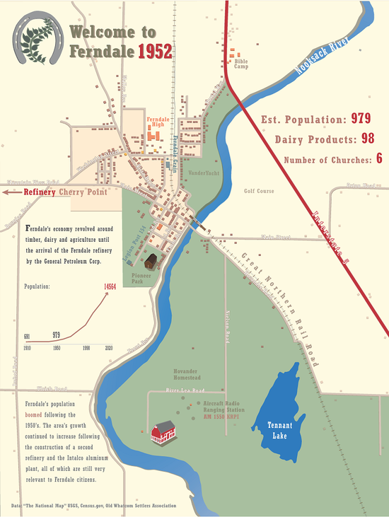
This workshop by Branden Rishel provided me with the necessary skills for integrating ArcGIS Pro projects and other media with Adobe Illustrator to create custom map graphics and visualizations.

ENVS 423 - GIS Processing and Analysis

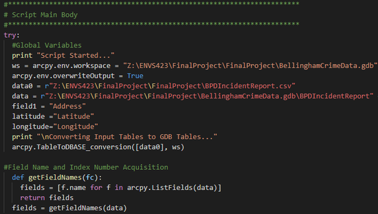
This course explored advanced ArcGIS techniques for data management and geoprocessing such as Python scripting, advanced use of ModelBuilder, scripting the creation of map documents, and using Python in open-source GIS software.

ENVS 421 - GIS IV: Advanced GIS Applications

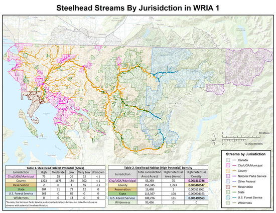
This course provided me with advanced knowledge in the use of geodatabases, ArcGIS ModelBuilder, geometric networks, linear referencing as well as fundamental satellite imagery utilization and interpretation and an introduction to ArcGIS Online.

ESCI 442 - Remote Sensing

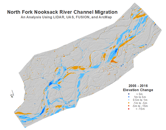
This course covered the theory of remote sensing, platforms, and image analysis techniques in ENVI including classification, spectral analysis, change detection, PCA, and image segmentation using Orfeo and R. We also analyzed LIDAR using USGS FUSION and sUAS structure-from-motion data using Agisoft Photoscan and ArcMap.

ENVS 420 - GIS III: Analysis and Modeling

This course provided me an in-depth examination of spatial data formats, spatial data analysis, and geoprocessing using ArcGIS and ModelBuilder.

Contact

  • Lynnwood, WA 98087